USACE Collaborates with Army on Climate Assessment Tool (ACAT) and Climate Resilience Handbook (ACRH)
Interest in understanding climate impacts to military installations, operations, and mission is growing within Congress and DoD. In response, the United States Army Corps of Engineers collaborated with the Army Office of Energy and Environment to develop and deploy the Army Climate Assessment Tool (ACAT). The ACAT contains authoritative, national data sets that inform eight climate hazard areas: heat impacts, drought, wildfire, energy demand, land degradation, riverine flooding, coastal flooding, and historic extremes. Planners can use these data as a screening tool to analyze their installation’s exposure to each hazard for future years 2050 and 2085, and under two different global greenhouse gas scenarios. The current version of ACAT includes installations within CONUS, AK, and HI, and will eventually include global installations.
The U.S. Army also published the Army Climate Resilience Handbook (ACRH). The ACRH guides installation planners through an assessment of climate risk to their facilities through an iterative, four step process. The ACRH then provides a detailed walkthrough of how the risk-informed planning process can be applied to an example installation. In September 2020, Army Directive (AD) 2020-08 required the use of the ACRH process, and the integration of ACAT results into all applicable plans, including property master pans, Integrated Natural Resource Management Plans, Installation Energy and Water Plans, emergency management plans, continuity of operations plans, and standard operating procedures.
|
 USACE Developing the Resilience Opportunity Identification (ROI) Tool USACE Developing the Resilience Opportunity Identification (ROI) Tool
Many government missions and operations are affected by changing climate, extreme weather, and other environmental conditions. As climate changes become more pronounced, these effects become more impactful, where organizations must develop practical, consistent, tailored, justifiable, and cost-effective climate adaptation measures that will reduce vulnerabilities and improve resilience. While Federal partnerships are an obvious solution, organizations may be familiar with only a few Federal agencies, and they may only have limited insight into grant programs.
The Resilience Opportunity Identification (ROI) Tool helps organizations identify optimal Federal partners for collaboration. Acting as a 'match-maker', the ROI Tool offers analytic insight into which Federal agencies have missions aligned to specific resilience needs. Under the hood, the ROI tool uses machine learning to evaluate both the Strategic Plans of candidate Federal agencies and the text pertaining to an organization’s mission requirements. The statistical model evaluates word usage and links words with learned thematic concepts, identifying core themes in each document, and scoring candidate agencies based on their thematic similarity to the organization’s mission.
With a better sense of the Federal landscape, organizations can more efficiently identify resilience funding opportunities. The ROI Tool can validate that resilience needs do in fact align with a specific agency's mission and capabilities. This can help a user refine his or her language usage and hone strategic messaging so that resilience needs are better scoped to specific mission sets and Federal capabilities.
|

USACE Releases the Sea Level Tracker on the Cloud
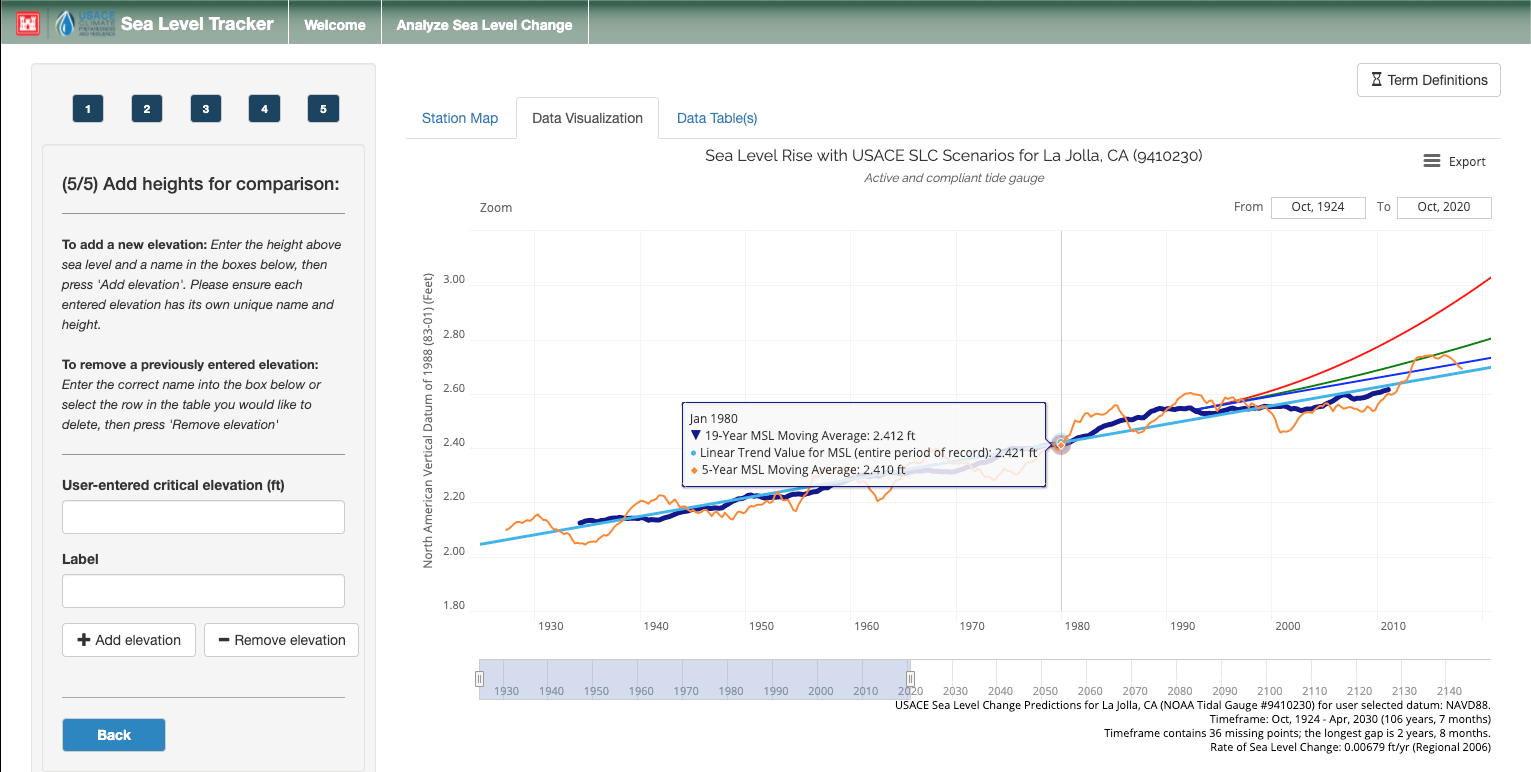
The United States Army Corps of Engineers finalized public, cloud-enabled release of the Sea Level Tracker. The Sea Level Tracker visualizes historical, observed changes in mean sea level (MSL) as measured and reported by National Oceanic Atmospheric Administration (NOAA) tide gauges, mapped against the USACE sea level change (SLC) projections. The tool enables the comparison of actual SLC with USACE SLC projections (as described in ER 1100-2-8162), along with observed monthly water levels and trends based on historical data. These components can help decision-makers can align various sea level change scenarios with existing and planned engineering efforts, estimating when and how the sea level may impact critical infrastructure and planned development activities.
Learn More
|