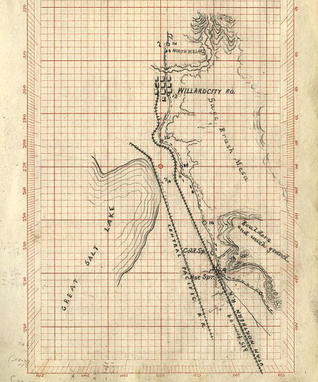
 North of Ogden Canyon to Camp no. 2 at North Willard, Utah, June 7, 1877, drawn by J.W. Ward. U.S. Geographical Surveys West of the 100th Meridian, Topographical Records, Book no. 294, Party no. 2, Utah Section, Office of History North of Ogden Canyon to Camp no. 2 at North Willard, Utah, June 7, 1877, drawn by J.W. Ward. U.S. Geographical Surveys West of the 100th Meridian, Topographical Records, Book no. 294, Party no. 2, Utah Section, Office of History |
|
One hundred and fifty years ago Lt. George M. Wheeler, Corps of Engineers, began exploring and surveying vast expanses of the American West. His expeditions over the course of nine years, 1871 through 1879, made up what was officially known as the U.S. Geographical Surveys West of the 100th Meridian but informally came to be called The Wheeler Survey. The survey took place at a time when the Army and civilian agencies were sponsoring expeditions to the western territories with various underlying military, transportation, economic, and settlement purposes. As a whole, these became known as the Great Western Surveys of the 19th century.
Wheeler, of course, did not operate alone. The multiyear endeavor required a great logistics effort to move and equip and supply the men who would constitute the field parties that actually performed the mapping and surveying. And in addition to the military members of the survey and the topographers, civilian scientists joined the groups. The expeditions were a superb natural laboratory for practical study by astronomers, paleontologists, zoologists, botanists, mineralogists, and others. Numerous clerks and "computers" performed the cataloging and calculating that was the basis of the annual reports and the survey's multivolume final report. Their participation and activities contributed immensely to the growing stock of scientific knowledge in America at that time, and after 150 years the joint nature of the endeavor serves as an example of the Corps of Engineers' dual military and civilian mission.
The Office of History (CEHO) has created four historical vignettes to tell the story of The Wheeler Survey. CEHO has relied primarily on sources from its own research and historical collections—documents, notebooks, photographs, and museum objects—supplemented with other academic works and imagery from outside sources.
|
|
 Sketch of Asturina nitida var-plagiata,, the gray hawk or Mexican goshawk, by Robert Ridgway. Plate No. 15, U.S. Geographical Surveys West of the 100th Meridian, Volume 5: Zoology, Sketch of Asturina nitida var-plagiata,, the gray hawk or Mexican goshawk, by Robert Ridgway. Plate No. 15, U.S. Geographical Surveys West of the 100th Meridian, Volume 5: Zoology,
Office of History |