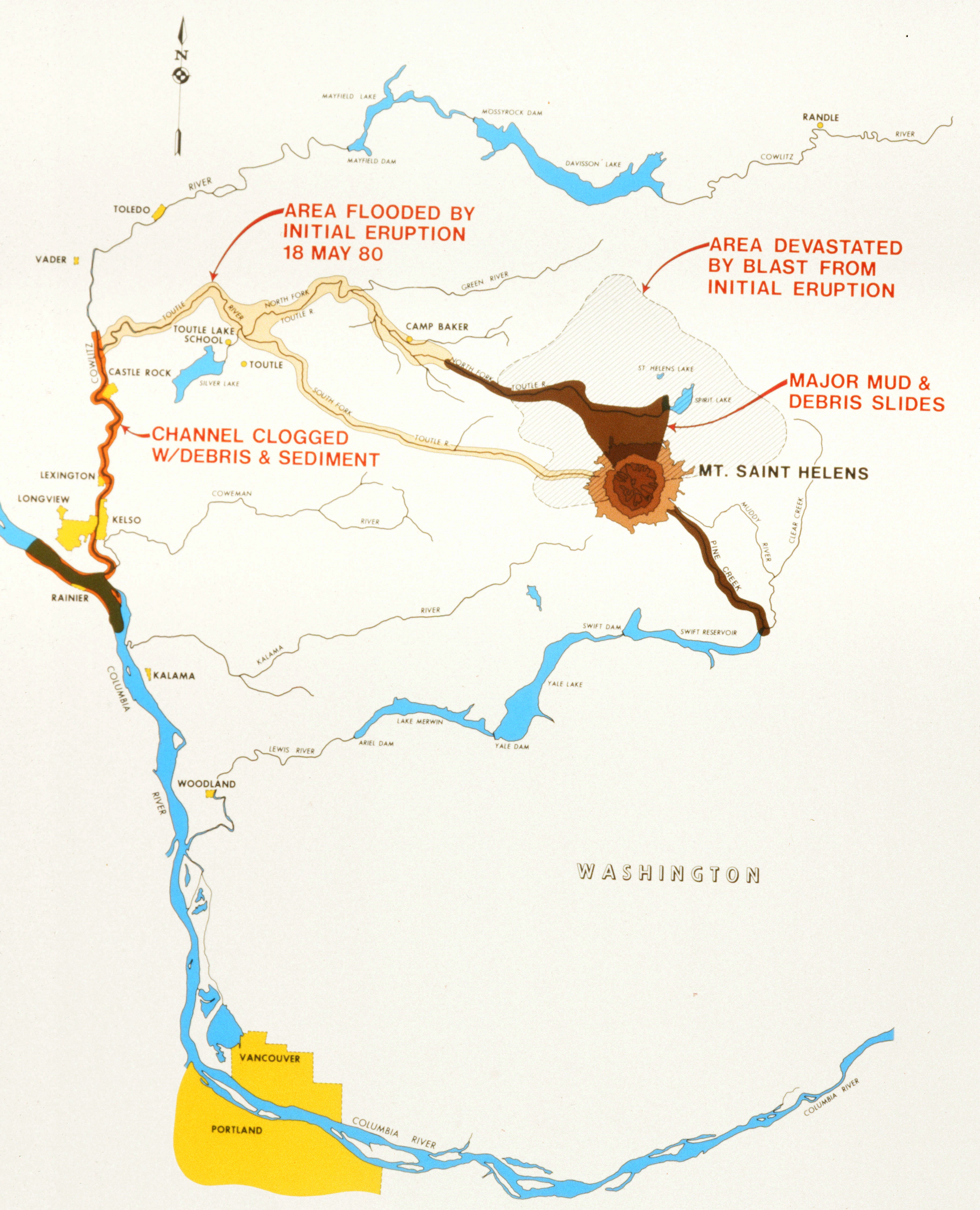
On May 18, 1980, Mount St. Helens—a volcano in Washington State located 96 miles south of Seattle and 50 miles northeast of Portland, Oregon—erupted violently. The ice-capped mountain had been recently stirring, sending up large plumes of ash and steam in March and shaking the ground repeatedly throughout the spring. Finally, on the morning of May 18, a significant earthquake collapsed a magma bulge on the mountain’s north side, sending an enormous avalanche of rock, trees, and glacial ice down the slopes. A massive explosion followed that flattened everything for miles in all directions and led to large mud flows. For hours the volcano spewed tons of ash into the air. The eruption and its aftermath killed fifty-seven people and countless wildlife and destroyed houses, bridges, railways, highways, and crops. Three days later, the Federal Emergency Management Agency (FEMA), only a year old at this point, declared the surrounding region a major disaster area.
The immediate consequences of the eruption were catastrophic, but the aftereffects were devastating as well, as debris from the volcano overran Spirit Lake and swept down the Toutle and Cowlitz Rivers, eventually reaching the Columbia River and disrupting river traffic. Ash and debris filled the Toutle River for approximately thirteen miles and covered the valley to an average depth of 150 feet. Mudflows blocked rivers, creating new and unstable upstream lakes. Flooding became a vital concern.
 |
|
The levee and the dredge spoils area at Lexington, Washington, on the Cowlitz River. CEHO
|
The Portland District of the Corps of Engineers responded immediately to the unfolding crisis. It turned its attention first to floods and to restoring navigability. Its neighboring districts in Seattle and Walla Walla conducted damage assessments in the affected regions. Corps personnel raised levees along the Cowlitz. They cleared debris from the Columbia and employed four hopper dredges and several contracted pipeline dredges to create an emergency navigation channel that allowed over 75 percent of the normal shipping traffic to resume by mid-June. With the initial emergency response successfully completed, the Corps turned to address mid-term problems such as flood threats from impounded waters and the continued sedimentation and debris flows into the area’s rivers.
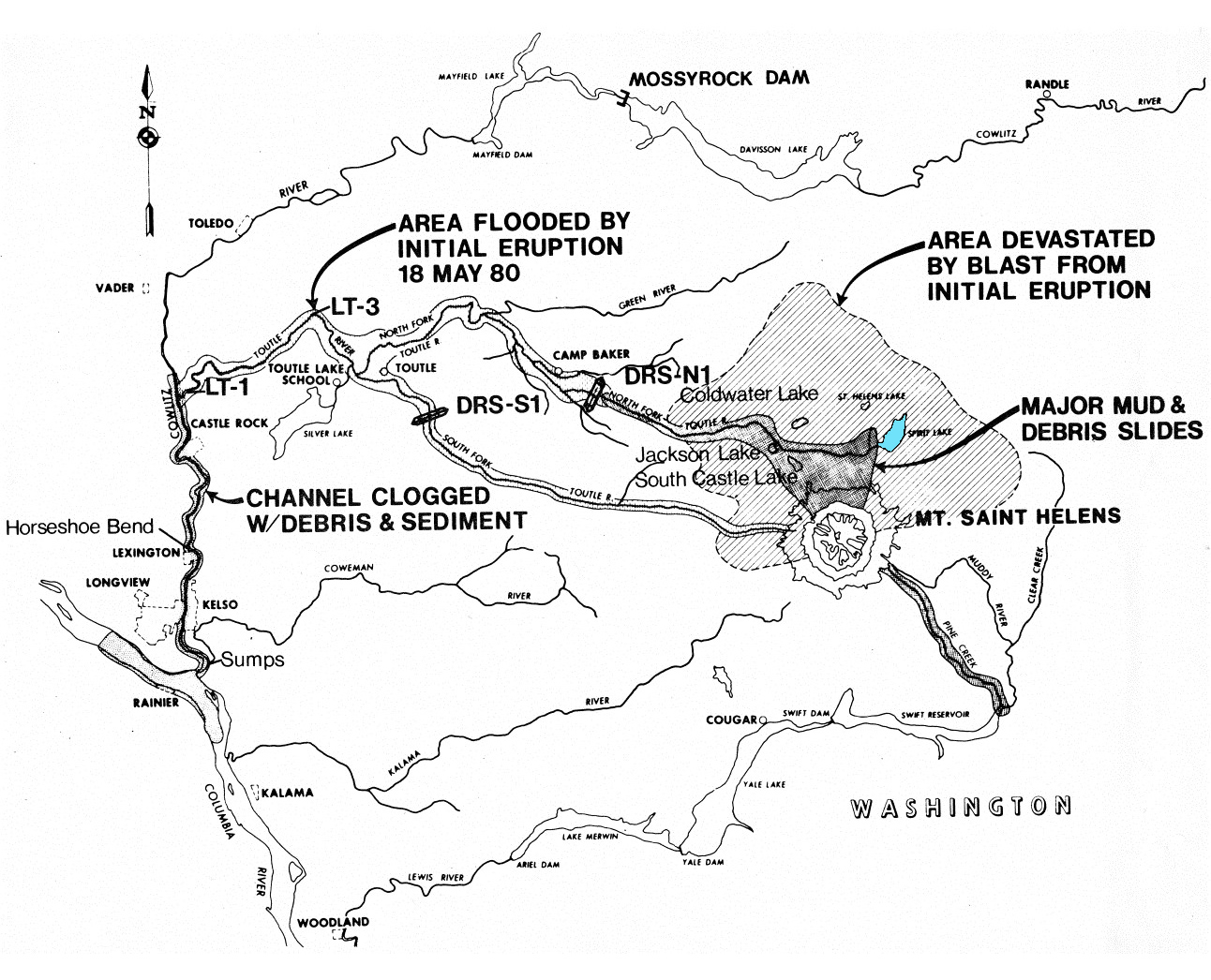
The volcano had disrupted the entire hydrological flow of the basin and, between June and November 1980, the Corps instituted a number of response measures. Corps and contractor personnel worked around the clock to clear debris and dredge navigation channels in the Cowlitz and lower Toutle Rivers, removing thirty-five million cubic yards of sediment and restoring the pre-disaster flow rate of the Cowlitz. The Corps also raised levees in the region to protect against potential flooding.
Because debris continued to erode and flow into rivers, the Corps constructed two temporary wire-and-rock dams to act as debris retaining structures on the forks of the Toutle River. Together the dams held back 600,000 cubic feet of sediment. Concurrently, the Corps managed the excavation of several stabilization basins along the Toutle. The basins trapped sediment, allowing for its removal, an effort that lasted through May 1981. These short-term responses—the dredging, levee improvements, debris dams, and sediment basins—cost approximately $327 million.
 |
 |
|
Dredging the Columbia River following the eruption. CEHO
|
Debris retaining structure on North Fork Toutle River. CEHO |
However, debris continued to pose longer-term threats, particularly at Spirit Lake, where impounded waters were rising dangerously. By November 1982, lake levels were so high that FEMA, fearing catastrophic flooding from a potential breach of the embankment, asked the Corps for solutions. Beginning that month, it deployed barge-mounted pumps to remove water from the lake. The effort was sufficient only to slow the water’s rise, not reverse it, but it gave planners time. The long-term solution took the form of an eleven-foot-diameter tunnel, a permanent outlet for the lake. Between September 1984 and March 1985, contractors bored through 1.5 miles of solid rock. The resulting outlet allowed water levels to drop by twenty feet and has worked well ever since.
To counteract ongoing sedimentation in the area’s rivers, the Corps devised a sediment retention structure on the Toutle’s north fork, and contractors began construction in December 1986. The structure—an embankment, outlet works, and a spillway—slowed the flow of water to allow debris to settle rather than be carried downstream. By November 1987 the structure had already begun to have a positive effect, even though its completion was two years off. It performed so successfully that by 2005 the sediment had built up above the structure sufficiently for the natural ecosystem in the area to rehabilitate.
 |
 |
|
Floating pump barge anchored in place on Spirit Lake with Harry's Ridge in the distance, 1982. CEHO
|
The Sediment Retention Structure on the North Fork Toutle River, showing sediment filling the river behind the ponded water. The outlet system and spillway are on the left. Built by the Granite Construction Co. for USACE. 1990. Portland District
|
Once again, the Corps of Engineers successfully responded to a catastrophic and, in this case, utterly unprecedented disaster. The Corps devised solutions, short term and long, and through its rapid mobilization and dedication to performing the job and completing the mission, fostered a renewed sense of normalcy in the area for the benefit and safety of all involved.
Learn about the ongoing work of Portland District to mitigate the effects of the disaster.
 |
 |
|
Maps of the area of devastation surrounding Mount St. Helens. The map on the right also shows the locations of the Sediment Stabilization Basins on the Lower Toutle (LT-1 and LT-2) and the S-1 and N-1 Debris Retention Structures. Spirit Lake is near the volcano in blue. CEHO
|
For more on the Corps of Engineers' emergency operations mission, see the Office of History publications Situation Desperate (Origins to 1950) and Destruction Imminent (1950 to 1979).
***
May 18, 2020. No. 137.