Redirecting...

2023 Announcements

USACE Launches New Sea Level Analysis Tool (SLAT)

The USACE Climate Preparedness and Resilience (CPR) Community of Practice (CoP) is launching the Sea Level Analysis Tool (SLAT) to help users integrate sea level change into the design of coastal projects.

Per USACE Engineer Regulation 1100-2-8162 and Engineering Pamphlet 1100-2-1, project delivery teams are required to include specific sea level change scenarios in the design of their projects. SLAT is designed to help users access and operationalize these scenarios.  The tool provides a user-friendly web application that enables users to visualize observed sea level data, compare observations to projected sea level change, and estimate when tidal and extreme water levels will intersect with elevation thresholds related to local infrastructure (e.g., roads, power generating facilities, dunes). In addition to the scenarios described in ER 1100-2-8162, SLAT allows users to access a variety of additional projections.

SLAT integrates and extends the features of two existing USACE tools: the Sea Level Change Curve Calculator and the Sea Level Tracker. It is designed to combine the quick performance of the Calculator with the feature availability of the Tracker, all while providing a refreshed and intuitive user interface.

SLAT can be accessed here: https://climate.sec.usace.army.mil/slat/


USACE Launches New Version of Climate Hydrology Assessment Tool (CHAT) on Amazon Web Services (AWS) Cloud

The USACE Climate Preparedness and Resilience (CPR) Community of Practice (CoP) is launching a new version of the Climate Hydrology Assessment Tool (CHAT) on the Amazon Web Services (AWS) cloud.

Engineering and Construction Bulletin (ECB) 2018-14 governs applications of climate change information to help inform hydrologic impacts to USACE Civil Works projects and studies. This guidance requires the assessment of historic and future (projected) conditions relevant to considering climate change as part of water resources studies and applications. The USACE-developed CHAT supports the application of ECB 2018-14. The tool is used to conduct climate change assessments performed by USACE, our partners, and our stakeholders. The CHAT offers a standardized and efficient approach to analysis and visualization of projected climate-changed hydrology and meteorology.

The latest version of the CHAT enables users to assess an expanded number of simulated historical and future (projected) climate-changed meteorologic and streamflow variables and includes enhanced options for visualizing these added time series. Users can now view streamflow variable outputs for a selected stream segment. Output for temperature and precipitation variables corresponds to a selected 8-digit HUC. When displaying streamflow output, the CHAT now enables the user to filter results by Representative Concentration Pathway (RCPs 4.5 and 8.5). Previously, annual-maximum of mean monthly streamflow outputs represented a combination of the projections generated using RCP 4.5 and RCP 8.5.  Robustness metrics have been added as an optional overlay to the annual time series plots. Robustness metrics are calculated for the mid-century and end-century epochs and assess whether there is inter-model agreement on the directionality of the future signal trend and whether the future signal trend is significant relative to the historic variability. In addition to visualizing the data over the entire simulation period (water years 1951–2099), users can now also view epoch-based changes in both annual and monthly variables for streamflow, temperature, and precipitation.

Access the new CHAT version: https://climate.sec.usace.army.mil/chat/


USACE Updates the Sea Level Tracker (SLT)

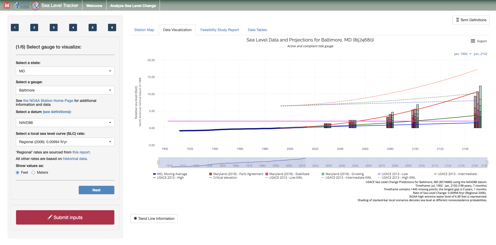
Screenshot of Sea Level Tracker, Baltimore MD Gauge

The USACE Climate Preparedness and Resilience (CPR) Community of Practice (CoP) is launching a new version of the Sea Level Tracker (SLT) on the Amazon Web Services (AWS) cloud. The new version of the tool integrates the functionality of a complementary tool, the Sea Level Change Curve Calculator (SLCCC), and adds new capabilities. Specifically, the new tool includes alternative projections of sea level from national and local sources. It also adds the capability to generate a downloadable report so that users can easily apply insights from the SLT to their projects.

As background, USACE has released formal guidance (e.g., USACE 1989, USACE 2013a, USACE 2013b, USACE, 2014) to incorporate sea level change (SLC) in project planning and design. Now, all current and future coastal projects must account for the impacts of changes in local mean sea level (LMSL) throughout a project lifecycle. USACE developed the Sea Level Tracker (SLT) to support the required analysis (per Engineer Regulation 1100-2-8162 and Engineer Technical Letter (ETL) 1100-2-1) and to empower deeper exploration of SLC more broadly.

The SLT allows users to visualize observed changes in sea level and to compare trends to projected changes. The tool shows historical, observed mean sea level (MSL) as measured and reported by National Oceanic Atmospheric Administration (NOAA) tide gauges, along with USACE SLC projections and calculated trends. Additionally, the tool can map these values against critical infrastructure elevation thresholds or other elevations of interest to the user. Finally, the tool enables users to visualize the indirect impacts of changing sea level on extreme water levels (EWLs) as calculated by NOAA and USACE.

Working together, these components can help users align various SLC scenarios with existing and planned engineering efforts, estimating when and how sea level may impact critical infrastructure and planned development activities.

Access the SLT here: https://climate.sec.usace.army.mil/slr_app/